GeoSection AutoCAD 2012

Professional graphic application aimed at construction and topography.
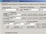
GeoSection is an excellent graphical application designed for civil engineering and surveying, which is oriented to the design of construction sites and overall topographic management. This GeoSection AutoCAD is specifically designed to be added to AutoCAD. It's entirely in Spanish.
Very briefly, with GeoSection AutoCAD you can perform the following: administration of survey projects, design points and vertices, control lines and polygonal subdivisions, design contours and digital terrain models, drawing topographic cross sections with specific tools, longitudinal profiles, calculation of volumes between cross sections and between grids, roads projects or any type of cross-section, levelling of agricultural land, etc.
With the tools that GeoSection AutoCAD comes equipped with you can also associate a defined plan with a file listing of longitudinal axis, draw cross-sectional diagrams, label the contour lines, define two opposite corners and align with a previously selected baselines, etc.
DownloadGeoSection AutoCAD 2012 related downloads


ACDSee Photo Manager 18
 Download
International versions of this excellent image administrator and viewer, with many supplementary functions.